Mountain
Magic Treks Pvt. Ltd.
Talk to an Expert (Rewati)
Magic Treks Pvt. Ltd.
Talk to an Expert (Rewati)
The Manaslu Circuit Trek offers a unique and less-traveled adventure through the serene Manaslu region, nestled amidst the majestic Himalayas. Unlike the popular Annapurna and Everest regions, the Manaslu area remains unexplored and untouched, making it a hidden gem for trekkers seeking solitude and natural beauty.
This 14-day trek takes adventurers on a journey from the west-central part of Nepal to the foothills of the world's eighth-highest mountain, Mt. Manaslu, standing at a towering height of 8,163 meters. The Manaslu Circuit Trek 14 days covers a distance of approximately 160 (Trekking except driving distance) kilometers as it circumnavigates the stunning Manaslu range in an anticlockwise direction.
The Manaslu Circuit Trek is a remarkable choice for those seeking an exceptional trekking experience in Nepal. It stands out for its isolation, off-the-beaten trails, and the sense of exploration it offers. The trekking routes were opened in 1991, making it a relatively new and undiscovered path. This journey promises not only breathtaking natural landscapes but also a deep cultural immersion into the lives of the Tibetan locals inhabiting the Manaslu region.
The trek is a journey of contrasts, with its route divided into two distinct halves.
The adventure commences with a scenic drive from Kathmandu to Soti Khola. This transition from urban surroundings to the natural beauty of the Himalayas is captivating in itself. From Soti Khola, the trek begins, leading through picturesque villages such as Machha Khola, Jagat, Deng, Namrung, Samagaon, Samdo, Dharamsala, and finally reaching the challenging Larkya La Pass. Along the way, trekkers traverse diverse landscapes, transitioning from sub-tropical jungles to alpine woodlands. En route, encounters with Tibetan Buddhist villages and the locals provide cultural insights. The apex of the trek is the Larkya La Pass, standing at a formidable altitude of 5,160 meters. This vantage point offers panoramic views of cerulean glaciers and towering mountains like Manaslu, Shringi Himal, and Himlung ranges.
The journey continues as trekkers bid farewell to the high altitudes and begin their descent. The path takes them through more captivating scenery until they reach Dharapani, marking the end of the trek. The nights spent reminiscing about the adventure are filled with a sense of accomplishment and a desire to return to explore further.
The Manaslu Circuit Trek poses challenges due to its off-beaten trails and demanding terrains. Trekkers must contend with steep and challenging paths, often covering around 15 kilometers for 5 to 6 hours per day. Successful completion of this trek requires a moderate level of fitness, cardiovascular exercises, flexibility, agility routines, and mental preparation. Determination and thorough understanding of the trek, its trails, infrastructure, and the region are essential for a safe and rewarding experience.
The trek follows a comprehensive itinerary that includes various waypoints and altitudes, ranging from 710 meters to the highest point, Larkya La Pass, at 5,160 meters. Acclimatization days and a gradual ascent help trekkers adapt to the changing altitudes. Each day's journey varies in distance and duration, providing a balanced trekking experience.
Nestled in the heart of the mighty Himalayas, the Manaslu Circuit Trekking offers adventurers an unparalleled experience of breathtaking landscapes, rich culture, and challenging terrains. Spanning 14 days from Kathmandu and back, this trek is a harmonious blend of natural beauty and cultural immersion.
Day 1: Kathmandu to Soti Khola (710m)
On day 1 of the Manaslu Circuit Trekking distance covered is approximately 140 kilometers (87 miles) from Kathmandu to Soti Khola. This journey involves a scenic drive that takes you from the bustling city of Kathmandu to the starting point of the trek in Soti Khola. The drive includes winding roads, picturesque landscapes, and a transition from urban surroundings to the natural beauty of the Himalayan region.
The drive typically takes around 7 to 9 hours, depending on road conditions and stops along the way. It's the first step of the incredible 14-day adventure that awaits trekkers on the Manaslu Circuit Trek.
Day 2: Soti Khola to Machha Khola (900m) – 9.7km
On Day 2 of trek to Manaslu Circuit, you'll cover a distance of approximately 9.7 kilometers (6.07 miles) as you trek from Soti Khola to Machha Khola. The trail follows the course of the Budi Gandaki river, and you'll traverse a variety of terrain, including rocky paths and lush forests.
The day starts with a gradual ascent from Soti Khola, and you'll cross several suspension bridges that offer breathtaking views of the river below. As you continue, you'll pass through quaint Gurung villages, terraced fields, and dense forests. The trail is dotted with tea houses and lodges where you can take breaks, rest, and enjoy local meals.
After trekking for about 6-7 hours, you'll arrive at the village of Machha Khola. The name "Machha Khola" translates to "Fish River" in English, and it refers to the river that flows through the village. This is a relatively short but moderately challenging day in terms of terrain, as there are both ascents and descents to navigate.
Throughout this leg of the journey, you'll get to immerse yourself in the local culture, enjoy the warm hospitality of the people living in these remote areas, and take in the natural beauty of the Himalayan foothills. This part of the trek offers a great introduction to the diverse landscapes and experiences that the Manaslu Circuit has to offer.
Overall, Day 2 is not only about covering the distance but also about embracing the experience and gradually adjusting to the trekking rhythm that will accompany you throughout the journey.
Day 3: Machha Khola to Jagat (1340m) - 22km
On Day 3 of the Manaslu Trek, you'll trek a distance of approximately 22 kilometers (13.7 miles) as you journey from Machha Khola to Jagat. This is a longer and more challenging day compared to the previous two, and you'll experience a significant change in altitude as well.
The trail continues along the Budi Gandaki river, and you'll encounter a mix of rocky paths, forests, and terraced fields.
The day's trek involves several ups and downs, crossing the river multiple times over suspension bridges. As you gain elevation, you'll notice shifts in the landscape and the architecture of the local villages.
You'll pass through villages like Tatopani, where you can take a break and soak in natural hot springs known for their therapeutic properties. Continuing on, you'll reach the village of Jagat at an altitude of 1340 meters. Jagat is a picturesque Gurung village with stone-paved streets, prayer wheels, and beautiful views of the surrounding mountains.
The journey from Machha Khola to Jagat takes approximately 8-10 hours, depending on your pace and the number of stops you make along the way. It's essential to stay hydrated, take short rests, and fuel yourself with local meals to keep your energy levels up.
As you trek on this day, you'll witness the cultural diversity of the region, interact with locals, and get a glimpse into their way of life. The dramatic changes in terrain and scenery will also keep you engaged and motivated as you push forward on your Manaslu Circuit adventure.
Day 4: Jagat to Deng (2095m) - 18km
On Day 4 of the Manaslu Circuit Trekking route, you'll cover a distance of approximately 17 kilometers (10.6 miles) as you trek from Jagat to Deng. This day's trek will continue to expose you to varying landscapes, cultural experiences, and an increase in altitude.
Leaving Jagat behind, the trail will take you through lush forests and charming villages. You'll ascend and descend on stone staircases, cross suspension bridges over the Budi Gandaki river, and pass through terraced fields. The trail offers a mix of gradual and steeper sections, providing both challenges and moments of respite.
As you hike, you'll notice the transition from the subtropical environment to a more temperate one. The villages will likely have a different feel in terms of architecture, culture, and even the crops grown in the area. You may encounter fellow trekkers along the way, fostering a sense of camaraderie and shared adventure.
The village of Deng, situated at an altitude of 2095 meters, is your destination for the day. This village is predominantly inhabited by the Gurung ethnic group. The unique architecture of the houses and the rich cultural practices of the residents make Deng a fascinating place to explore.
The trek from Jagat to Deng typically takes around 6-8 hours, depending on your pace and the time you spend exploring the surroundings. It's important to stay mindful of your body's adjustment to the increasing altitude and to take it slow to prevent altitude-related issues.
Throughout this leg of the journey, the ever-changing scenery and the warmth of the local people will keep you motivated. The sense of achievement as you arrive in Deng will be accompanied by the anticipation of further adventures on the Manaslu Circuit Trek.
Day 5: Deng to Namrung (2630m) - 13km
On Day 5 of the Manaslu Circuit Trek, you'll cover a distance of approximately 11 kilometers (6.8 miles) as you trek from Deng to Namrung. This day's trek continues to offer a mix of natural beauty, cultural exploration, and a gradual increase in altitude.
Leaving Deng behind, you'll follow the trail that winds through forests, crosses bridges, and provides occasional views of the surrounding mountains. As you ascend higher into the Manaslu Conservation Area, you'll notice changes in the landscape, including the vegetation and the architecture of the villages.
The trail will lead you through quaint villages like Namrung, where you'll get a glimpse into the daily lives and traditions of the local people, who are primarily of Tibetan origin. The village is adorned with prayer flags and Mani walls, adding a spiritual touch to the journey.
Namrung, situated at an altitude of 2630 meters, offers stunning views of the nearby mountains, and you might start to feel the crispness of the high-altitude air. The surrounding landscapes and the hospitality of the people make this a rewarding place to spend the night.
The trek from Deng to Namrung usually takes around 5-7 hours, depending on your pace and the time you spend interacting with the locals or simply enjoying the scenery. As you gain elevation, be sure to stay hydrated and listen to your body's signals.
Each day of the Manaslu Circuit Trek unveils more of the Himalayan region's beauty and charm, and Day 5 is no exception. From the lush forests to the rugged terrain, every step takes you further into the heart of the mountains, creating memories that will last a lifetime.
Day 6: Namrung to Samagaon (3530m) - 15km
On Day 6 of the trek to Manaslu, you'll cover a distance of approximately 15 kilometers (9.3 miles) as you journey from Namrung to Samagaon. This part of the trek offers not only a longer distance but also a significant increase in altitude, as you venture deeper into the stunning landscapes of the Manaslu region.
Leaving Namrung behind, the trail gradually ascends through alpine forests and charming villages. You'll pass by the village of Lihi, with its intricate stone walls and close-knit houses. The trail offers breathtaking views of the surrounding mountains, including Manaslu itself, as well as the Ganesh Himal range.
As you continue, you'll cross the famous Budhi Gandaki River and enter the village of Sho, which presents you with more opportunities to interact with the locals and learn about their culture and way of life. The trail then leads you to Lho, where you can visit the monastery and immerse yourself in the spiritual atmosphere.
From Lho, it's a steady climb to Shyala, where the Samagaon valley opens up before you. The sight of Samagaon, with its traditional houses and monasteries set against the backdrop of the Himalayas, is awe-inspiring.
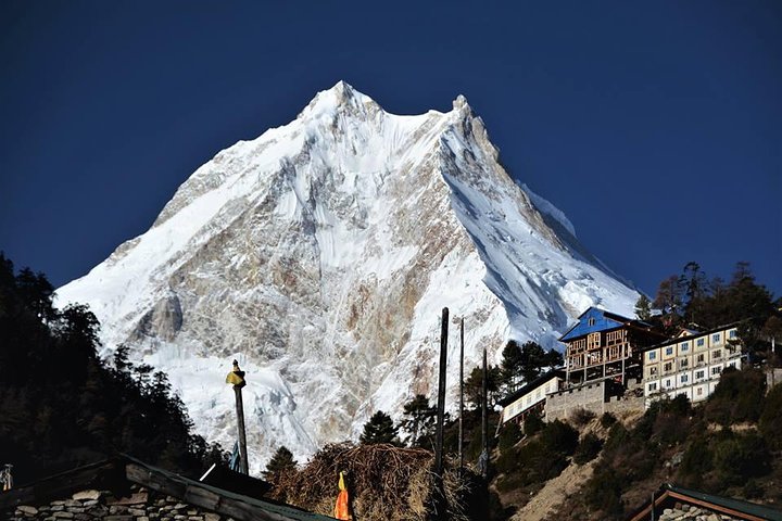
Samagaon, your destination for the day, is situated at an altitude of around 3530 meters. This charming village is one of the largest in the region and serves as a hub for trekkers and mountaineers. You'll find teahouses, shops, and basic amenities here, making it a great place to rest and acclimatize before further ascending on the trek.
The trek from Namrung to Samagaon is not just about covering the distance; it's about embracing the change in scenery, interacting with the locals, and experiencing the Himalayan way of life. The trail's beauty and the warm hospitality of the people will keep you motivated as you continue your trekking adventure in the Manaslu region. This leg of the journey usually takes around 6-8 hours, depending on your pace and the time you spend exploring the villages along the way.
Day 7: Acclimatization Day in Samagaon
Use this day to adjust to the altitude. Explore Samagaon, interact with the locals, and hike to higher altitudes for better acclimatization. The surrounding vistas provide a sense of serenity.
Day 8: Samagaon to Samdo (3860m) - 10km
On Day 8 of the Manaslu Circuit Trek, you will cover a distance of approximately 10 kilometers (6.2 miles) as you make your way from Samagaon to Samdo. While the distance may not be very long, the increase in altitude adds an additional challenge to the trek.
Leaving Samagaon behind, the trail gradually ascends along the Budhi Gandaki River. You'll be treated to stunning views of the surrounding mountains and the picturesque landscape. As you continue, you'll pass through juniper and birch forests, adding to the natural beauty of the journey.
The highlight of the day is the crossing of the Larke Khola over a wooden bridge. The trail then leads you to Kermo Kharka, a seasonal grazing settlement. From here, you'll ascend further until you reach the village of Samdo.
Samdo is situated at an altitude of approximately 3860 meters (12,664 feet) and serves as an important acclimatization stop. The village is located near the Tibetan border and offers spectacular views of the Himalayan peaks. The day's trek might take around 4-6 hours, depending on your pace and the time you spend admiring the scenery and taking photos.
Upon reaching Samdo, you'll have the opportunity to rest and acclimate to the higher altitude. It's important to take it easy and stay hydrated.
You can explore the village, interact with the local people, and learn about their unique culture and way of life. Samdo is also known for its yaks, so you might come across these hardy animals grazing in the vicinity.
The trek from Samagaon to Samdo might be relatively short in terms of distance, but the change in altitude and the breathtaking mountain vistas make it a memorable part of the Manaslu Circuit Trek. It's essential to listen to your body, acclimatize properly, and fully enjoy the remarkable landscapes that this region has to offer.
Day 9: Samdo to Dharamsala (4460m) - 11km
On Day 8 of the Manaslu Circuit Trek, you'll be covering a distance of about 11 kilometers (6.8 miles) as you trek from Samdo to Dharamsala, also known as Larkya Phedi. This part of the trek is essential as you continue to gain altitude and prepare for the challenging Larkya La pass.
Leaving Samdo behind, the trail ascends gradually, offering stunning views of the surrounding mountains. You'll be walking on rocky terrain as you make your way towards Dharamsala. The trail passes through high alpine areas, and you might notice a decrease in vegetation due to the higher altitude.
Dharamsala, situated at an altitude of 4460 meters (14,632 feet), is the last lodge stop before crossing the Larkya La pass. The trek might take around 4-6 hours, depending on your pace and the weather conditions. The accommodation at Dharamsala is very basic, as it primarily serves as a resting point for trekkers preparing for the pass.
As you approach Dharamsala, you'll catch sight of the majestic Larkya Glacier and the snow-covered peaks in the vicinity. The lodge at Dharamsala provides a cozy place to rest, have warm meals, and spend the night. Due to the high altitude and the impending pass crossing, it's crucial to stay hydrated and listen to your body.
The day's trek is not only about covering distance but also about acclimatizing and mentally preparing for the challenging Larkya La pass that you'll be crossing on the following day. Take this time to rest, take in the breathtaking views, and mentally gear up for one of the most remarkable sections of the entire Manaslu Circuit Trek.
Day 10: Dharamsala to Bimthang (3590m) via Larkya La Pass (5160m) - 24km
On Day 10 of the Manaslu Circuit Trek, you're in for a challenging and breathtaking journey as you cover a distance of approximately 24 kilometers (14.9 miles) from Dharamsala to Bimthang via the formidable Larkya La Pass.
The day begins early in the morning as you prepare for the exhilarating crossing of the Larkya La Pass, which stands at a formidable altitude of 5160 meters (16,929 feet). The pass is the highest point of the entire trek and offers panoramic views of the surrounding Himalayan peaks, including Himlung Himal, Cheo Himal, Kang Guru, and Annapurna II. The sunrise from this vantage point is an unforgettable sight.
The trek to Larkya La is challenging and requires physical stamina and mental determination. The trail gradually ascends as you make your way up the pass. Depending on the time of year and weather conditions, the pass may be covered in snow, adding to the adventure and difficulty of the trek.
Once you conquer the Larkya La Pass, you'll begin your descent towards Bimthang. The trail takes you through rocky terrain, moraines, and eventually, lush forests. Bimthang, situated at an altitude of 3590 meters (11,778 feet), is a welcome sight after the challenging pass crossing. The total trekking time for the day can range from 8 to 10 hours, depending on various factors.
The village of Bimthang is surrounded by stunning landscapes and offers a peaceful atmosphere.
You'll be rewarded with magnificent views of Mt. Manaslu, Lamjung Himal, and other nearby peaks. Bimthang serves as a great place to rest, reflect on your accomplishment, and rejuvenate for the remaining days of the trek.
Day 11: Cross over Larkya-la 5,135m and trek to Bimthang 3720 m/ 9 hrs.
On Day 11 of the Manaslu Circuit Trek, you're in for a challenging and breathtaking journey as you cover a distance of approximately 24 kilometers (14.9 miles) from Dharamsala to Bimthang via the formidable Larkya La Pass.
The day begins early in the morning as you prepare for the exhilarating crossing of the Larkya La Pass, which stands at a formidable altitude of 5160 meters (16,929 feet). The pass is the highest point of the entire trek and offers panoramic views of the surrounding Himalayan peaks, including Himlung Himal, Cheo Himal, Kang Guru, and Annapurna II. The sunrise from this vantage point is an unforgettable sight.
The trek to Larkya La is challenging and requires physical stamina and mental determination. The trail gradually ascends as you make your way up the pass. Depending on the time of year and weather conditions, the pass may be covered in snow, adding to the adventure and difficulty of the trek.
Once you conquer the Larkya La Pass, you'll begin your descent towards Bimthang. The trail takes you through rocky terrain, moraines, and eventually, lush forests. Bimthang, situated at an altitude of 3590 meters (11,778 feet), is a welcome sight after the challenging pass crossing. The total trekking time for the day can range from 8 to 12 hours, depending on various factors.
The village of Bimthang is surrounded by stunning landscapes and offers a peaceful atmosphere. You'll be rewarded with magnificent views of Mt. Manaslu, Lamjung Himal, and other nearby peaks. Bimthang serves as a great place to rest, reflect on your accomplishment, and rejuvenate for the remaining days of the trek.
Day 11 is undoubtedly one of the most demanding and memorable segments of the Manaslu Circuit Trek. It's a testament to your endurance and a chance to witness the awe-inspiring beauty of the Himalayas. As you settle in at Bimthang, take some time to soak in the incredible scenery and relish in the sense of achievement that comes with conquering the Larkya La Pass.
Day 12: Bimthang to Gho (2300m) - 14km
On Day 12 of the Manaslu Circuit Trek, you will be trekking from Bimthang to Gho, covering a distance of approximately 14 kilometers (8.7 miles).
The trail from Bimthang to Gho takes you through picturesque landscapes, charming villages, and diverse terrain. You'll descend from the higher altitudes of Larkya La Pass and continue your journey through lush forests, rocky paths, and occasional meadows.
As you trek further, you'll pass through villages like Tilije, where you can experience the local culture and interact with the friendly inhabitants. The trail offers a mix of gradual descents and flat sections, making it a relatively moderate day of trekking compared to some of the more challenging previous days.
The village of Gho is situated at an altitude of 2560 meters (8398 feet) and provides a more comfortable and warmer environment compared to the higher altitudes. Gho is known for its cozy teahouses and lodges, offering trekkers a well-deserved rest. The entire trek can take around 6 to 8 hours, depending on your pace and the trail conditions.
During this leg of the trek, you'll have the opportunity to enjoy the changing scenery and immerse yourself in the rural lifestyle of the region. The beauty of the Manaslu region will continue to unfold as you make your way towards Gho, marking another memorable day of your Manaslu Circuit adventure.
Day 13: Gho to Dharapani (1860m) - 17km
On Day 13 of the Manaslu Circuit Trek, you will be trekking from Gho to Dharapani, covering a distance of approximately 12 kilometers (7.5 miles).
The trail from Gho to Dharapani takes you through a mix of terrains and landscapes, as you continue your descent through the enchanting Manaslu region.
The route passes through charming villages, lush forests, and alongside the gushing Marsyangdi River.
As you trek further, you'll traverse through villages like Tilije and Thonje, where you can experience the local culture and architecture. The trail also merges with the Annapurna Circuit Trek route, and you'll begin to encounter more trekkers coming from different trails.
Dharapani, situated at an altitude of 1860 meters (6102 feet), is a popular trekking hub and a checkpoint where you'll need to register your permits.
The village offers basic amenities such as teahouses, lodges, and shops, making it a comfortable place to rest after a day of trekking.
The entire trek from Gho to Dharapani can take around 5 to 7 hours, depending on your pace and the trail conditions. This day's trek is relatively moderate with some gradual descents and flat sections, allowing you to enjoy the stunning scenery and immerse yourself in the local culture.
As you approach Dharapani, you'll also notice the change in vegetation and landscape as you descend to lower altitudes.
This part of the trek offers a nice contrast to the higher altitudes you've experienced earlier in the circuit.
Overall, Day 13 will be a fulfilling day of trekking, offering you a glimpse of both natural beauty and the cultural richness of the Manaslu and Annapurna regions.
Day 14: Dharapani to Besisahar and Back to Kathmandu
On Day 14 of the Manaslu Circuit Trek, you will travel from Dharapani to Besisahar and then again travel back to Kathmandu. This day involves a combination of driving.
The driving distance from Dharapani to Besisahar is approximately 25 kilometers (15.5 miles). The road follows the Marsyangdi River, passing through various villages and picturesque landscapes.
You'll retrace some of the path you took at the beginning of the drive, giving you a chance to reflect on the amazing journey you've undertaken over the past two weeks.
The ride from Dharapani to Besisahar can take around 3 to 4 hours, depending on your pace and road conditions. Since this is a long driving day, it's important to start early in the morning to give yourself plenty of time to reach Besisahar by lunch time.
Once you reach Besisahar, you'll take a private vehicle or a local bus to travel back to Kathmandu. The distance from Besisahar to Kathmandu is approximately 175 kilometers (109 miles), and the journey by road usually takes around 5 to 6 hours, depending on the road conditions and traffic.
This day is primarily a travel day, and you'll have the opportunity to rest during the road journey back to Kathmandu. You can enjoy the changing scenery outside the window, reflecting on the incredible adventure you've had in the Manaslu region.
Upon your return to Kathmandu, you can celebrate the successful completion of the Manaslu Circuit Trek and reminisce about the breathtaking landscapes, diverse cultures, and memorable experiences you encountered along the way.
In conclusion, Day 14 is a combination of trekking from Dharapani to Besisahar and then traveling by road back to Kathmandu. It marks the end of your Manaslu Circuit Trek and provides you with a final opportunity to soak in the beauty of Nepal's landscapes before returning to the bustling city life of Kathmandu.
The Manaslu Circuit Trek, spanning 14 days, is not just a physical journey but a spiritual and cultural odyssey. It takes you through diverse landscapes and introduces you to the warm hospitality of the local communities. Each step brings you closer to the heart of the Himalayas, leaving you with memories to cherish for a lifetime.
The Manaslu Circuit Trek is best undertaken during the autumn (September to November) and spring (March to May) seasons when weather conditions are favorable, skies are clear, and natural beauty is at its peak. Altitude sickness is a significant concern due to the varying altitudes encountered during the trek. Trekkers must be aware of the symptoms and take preventive measures such as proper acclimatization, hydration, and appropriate medical supplies.
The Manaslu region offers several other treks, including the Manaslu Tsum Valley Trek, Manaslu Circuit and Tsum Valley Trek, Manaslu Circuit Trek, and Short Manaslu Circuit Trek Each trek provides a unique adventure, cultural experiences, and breathtaking views.
Packing for the Manaslu Circuit Trek requires careful consideration of clothing, equipment, personal supplies, and general medications. High-quality gear ensures a comfortable and safe journey. Trekkers should maintain a balanced backpack, avoiding unnecessary items.
The Manaslu Circuit Trek presents an opportunity to explore the lesser-known beauty of the Himalayas. This trek offers a blend of natural landscapes, cultural interactions, and personal challenges. As trekkers traverse through varied altitudes, they witness the stunning grandeur of the Manaslu region and its captivating surroundings. Proper preparation, respect for the environment, and an adventurous spirit are the keys to a successful and unforgettable journey through the heart of the Himalayas.
© 2011 - 2024 All rights reserved. Mountain Magic Treks Pvt. Ltd. Developed By : Xenatech Nepal